WEATHER: Potential flood warnings as prolonged rain forecast for Yorkshire Coast
and live on Freeview channel 276
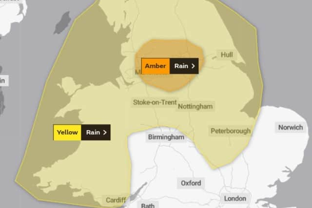
The Met Office has said that heavy downpours combined with melting snow if likely to lead to some flooding in North Yorkshire.
The warning come into force at 00:00 (UTC) on Tuesday January 19 and remains in place until 12:00 (UTC) on Thu January 21.
Advertisement
Hide AdAdvertisement
Hide AdThe meteorological organisation said the following could be expected:

- Homes and businesses could be flooded, causing damage to some buildings
- Fast flowing or deep floodwater is possible, causing a danger to life
- Delays or cancellations to train and bus services are possible
Advertisement
Hide AdAdvertisement
Hide Ad- Spray and flooding could lead to difficult driving conditions and some road closures
- Some communities may be cut off by flooded roads
- Possible power cuts and loss of other services to some homes and businesses
Further details
Several days of persistent and occasional heavy rain are expected to affect the region.
The heaviest and most persistent rain is likely to be across Wales and the high ground of northern England (Pennines).
Advertisement
Hide AdAdvertisement
Hide AdBy early Thursday, 30-60 mm of rain is expected to fall widely across the warning area, with 100-150 mm over the high ground of Wales and northern England.
Up to 200 mm is possible across parts of north Wales.
Melting snow across higher parts of the Pennines may exacerbate the potential for flooding.
Strong winds will also accompany the rainfall and may add to travelling difficulties across areas higher and more exposed routes.
The weather for Yorkshire and Humber for the week ahead reads:
Headline:
Advertisement
Hide AdAdvertisement
Hide AdBrightest in east, patchy rain in west. Wetter towards midweek.
Monday:
On the cloudy side at times, this mainly in the west with patchy rain here. Often drier and brighter in the east, perhaps more generally so in the afternoon, ahead of cloud spreading northeast into the evening. Maximum temperature 8 °C.
Monday night:
Soon becoming cloudy as rain spreads northeast, becoming increasingly heavy and persistent later in the night. Frost probably very limited given increasingly unsettled conditions. Minimum temperature 2 °C.
Tuesday:
Potentially very wet, with a band of persistent, occasionally heavy rain stalling over the region, seeing out the day. Rather cold in the north, milder but breezy in the south. Maximum temperature 11 °C.
Outlook for Wednesday to Friday:
Heavy, persistent rain likely continuing Wednesday. Notably colder Thursday, with a risk of gales and some snow, ahead of a brighter but colder end to the week with wintry showers.
Comment Guidelines
National World encourages reader discussion on our stories. User feedback, insights and back-and-forth exchanges add a rich layer of context to reporting. Please review our Community Guidelines before commenting.